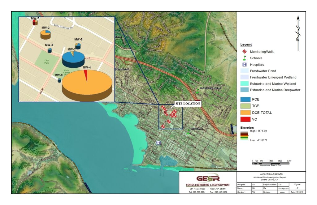
A picture is worth a thousand words and mapping environmental data, contaminant plumes, source areas, landforms, land types, vegetation, and specific habitats using our Geographic Information System(s) often eliminates the need for lengthy text discussions. Consequently, our reports and data analysis are visually oriented, employing high-quality mapping to illustrate key points and punctuate conclusions.
This approach makes our documents user-friendly and easily understood by the non-scientist as well as those familiar with GIS. GIS techniques also provide landscape to site scale connectivity and allows us to maintain continuity and context throughout our site assessment and characterization work.
At GE&R, we understand the hallenges that you face when acquiring, divesting, developing, or selling environmentally impaired real estate. Dealing with environmental liability is like opening Pandora’s box. These legacy liabilities change balance sheets and inhibit growth potential. With GE&R on your team you can transform that liability into an asset and stabilize your balance sheet today.
Geographic Information Systems (GIS) have become an essential tool for any decision making process that involves a geographic or spatial component. GE&R specializes in environmental uses of GIS, with additional capabilities extending to many GIS, CAD and graphic applications. GE&R uses state-of-the-art mapping software and hardware to perform analysis and mapping to ensure that clients receive the highest quality product available.
GE&R provides complete in-house mapping services or can coordinate with our clients who have CAD/GIS capabilities. Our GIS/GPS field professionals are knowledgeable of environmental resource issues, and our in-house expertise reduces the potential for error associated with collecting large amounts of data. GE&R has completed projects including small acreage residential sites, large-scale multidisciplinary projects, GIS analysis and interpretation, aerial photograph interpretation and digital manipulation, and GIS analysis for transportation and utility corridor planning.
GE&R’s GIS team specializes in GIS data creation and analysis, environmental impact reports, and municipal data development. Our team has an extensive background in cartographic presentation, a thorough understanding of environmental GIS techniques, and familiarization with the latest GIS/GPS software and applications.
GE&R provides a full range of comprehensive GIS consulting services, including:
- 3D and spatial analyses and mapping
- Watershed analysis and mapping
- Environmental impact analysis
- Terrain modeling and analysis
- Resource mapping
- Field data acquisition/GPS data collection
- GIS, AutoCAD and Microstation data acquisition and manipulation
- Asset mapping/inventory analysis
- Digitizing from source media
- Geocoding
- Georeferencing
- Data migration/data format conversion
- Cleaning of geographic data for use in CAD or GIS applications
- Internet mapping site creation
- Geodatabase creation
- Metadata creation